
Factory Aerials from 1940s
We have a set of 24 aerial photographs of the Maffra factory area, taken about 1945-1946 by the RAAF Base at East Sale. These came out of a good camera, and while we cannot quite read the registration numbers on the trucks (!), they are pretty special.
And so is our secretary/treasurer, Spencer, who started work at the Maffra Co-op in 1946, and was there for fifty years. His knowledge of the area is invaluable.
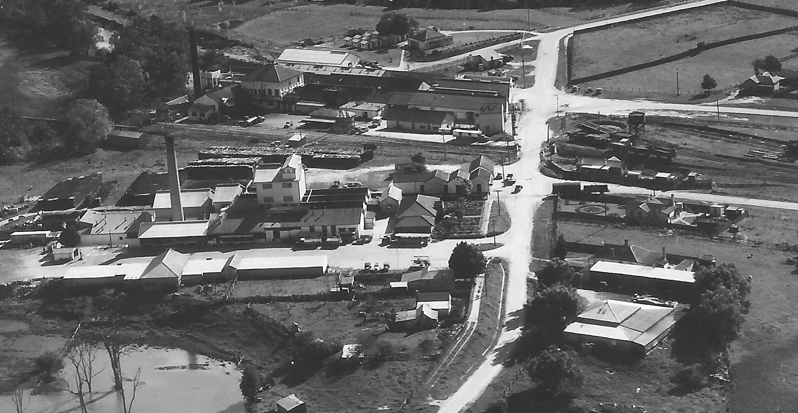
In this one, above, cropped from a larger photo, the Maffra Co-op is in the foreground, with Nestles on the other side of the railway line.
On the left of Bundalaguah Road, which passes the two factories, are two houses in the foreground. The first was the Merlo family, the second a man whose name Spencer cannot recall – but he remembers he milked a cow in the back yard.
Passing Nestles, in the small triangle of land is a factory built in 1891 as the first dairy factory in the town – the Melbourne Fresh Food and Frozen Storage Company. It closed in 1896, and later became the cordial factory.
Behind it is the Nestles hostel, with the single men's huts.
On the other side of Bundalaguah Road, going towards the town, the large building is the old Nestles stables, from the time they collected milk cans with a horse and cart. The next shed is probably part of that complex too, next to the where Kris Bodenstaaf lived as the Nestles foreman.
Next is the station master’s house, with its ornate garden, and across Railway Place, the railway gate-keeper’s house. Mr Hill, who had lost both his legs, was one gate-keeper.
On the other side of the railway line is the turntable, where locomotives were turned around to face the opposite direction.
Finally, across Station Street was a house where we are still looking for names for the occupants. Can anyone help?
Out of the picture, on the right, are the railway station, the wine saloon, Willsmere, the sugarbeet factory and the dehydration factory (now The Shed). We have them in other photographs in the set.
So, how did we do the identifications?

We sat around the big table in the Library, and projected the photographs up on a small screen, and everyone had a go at them. Library staff put up a sign at the desk inviting people to join in, and a few did. They are good like that, our Library people. All in all - a good afternoon's work.
posted by Linda | 1:27 PM
|
0 comments
![]()